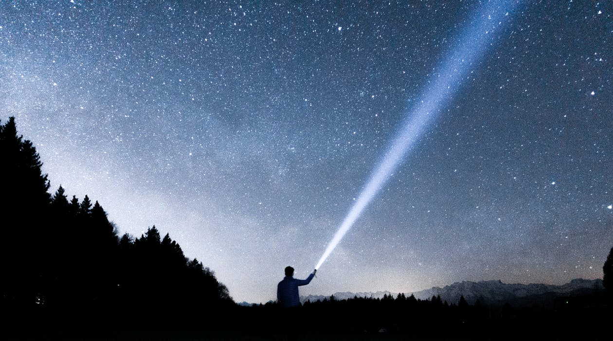
We all enjoy gazing at a clear sky full of stars.
And while the sky is impressive in its magnificence, especially on a clear night, it can be so much more than that.
In fact, the sky, and the way the stars are arranged, can also be used for navigation.
In essence, celestial navigation is one of the oldest practices in human history. Early navigators would use the constellations and determine their location and where they were heading.
This guide aims at providing a comprehensive overview of celestial navigation so that you can better understand this ancient practice.
The heavens call to you and circle about you, displaying to you their eternal splendors… (Dante, Purgatorio, Canto XIV)
So, here is your guide to astronavigation demystified!
What Is Celestial Navigation?

How could we define celestial navigation?
Also referred to as astronavigation, it represents the practice of position fixing, enabling the navigator to travel without the need to consider estimated calculations to assess his/her position.
To that end, one way to define celestial navigation is that it uses angular measurements or sights for navigation.
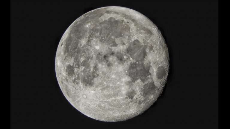
These angular measurements are established between different celestial bodies – namely the sun, the moon, the planets, or a star, and the visible horizon.
The sun is the most frequently utilized.
Nevertheless, navigators would also depend on the moon, different planets, Polaris, or one of the 57 individual navigational stars.
The coordinates of the stars were incorporated in nautical and air almanacs.
Celestial navigation history is, undoubtedly, a source of fascination. The very first seafarers made sure to never lose track of the land.
That was, ultimately, one of the essential elements of successful navigation.
For instance, the Greeks have learned how to navigate in their archipelago, from an island to the next. And when there was no land nearby, they would look at the sky.
The philosopher Thales of Miletos reckoned that constellations could be used as a means of navigating.
To that end, he taught Ionian sailors that they should assess the Little Bear Constellation to navigate. This was 600 years before Christ.
Considering that certain stars are relatively fixed markers, people have oriented themselves depending on the position of the stars from the beginning of history.
You could argue that knowing as much as possible about celestial navigation is one of the essential skills of an outdoor enthusiast.
Just as you should know how to create a medical survival first-aid kit and know the basics of making a lasting campfire.
Of course, you don’t become a campfire master overnight – this is a skill you can develop over time, with perseverance and commitment.
The same could be said about celestial navigation, which is a challenging skill to master, but it is worth the effort. In time, it can turn out to be really useful during camping, trekking, or any other type of outdoor adventurous activity.
As a matter of fact, if you’re passionate about night hiking, knowing the basics of celestial navigation, which we will cover below, is highly recommended.
Plus, you should avoid making a bunch of essential mistakes to stay on the safe side.
One major mistake would be not having essential gear with you or failing to bring appropriate equipment.
How Does Celestial Navigation Work?
Celestial navigation is an intuitive means of navigation.
Having existed before the invention of north, south, right and left, it is based on a quintessential rule.
So, the key rule to celestial navigation is having a fixed, known reference point.
But where did this reference point come from, prior to the invention of compasses or anything of the kind?
The Pole Star was seen as what we today call North.
Even nowadays, the North – by extension, the North Star, represents the singular universal point of reference on Earth.
The same could be said about the South Star – namely Sigma Octantis – which is characteristic of the Southern Hemisphere.
That being said, ancient celestial navigation didn’t provide information regarding your exact position.
As a matter of fact, it had little to do with your position vector.
Before the invention of watches and calendars, the moon, the sun and the stars were the only timekeepers you could depend on.
On that note, you had to fix two reference points on the sky – such as the moon and a known star.
After doing that, you assess the angular measurement between the two celestial bodies.
It is fascinating to see that the angle between the moon and Regulus, for instance, would be the same in the Indian Ocean as it would be in any other location on earth.
In addition to that, the angle between the moon and Regulus is unique for that specific time in space, the angle is the same, regardless of the place from which you observe it in the world.
At a specific time, each individual celestial body has a geographic position (GP) that is assessed according to its latitude and altitude.
In other words, the angle between the visible horizon and the celestial body is linked with the distance between the observer’s location and the geographic position of the celestial body.
The Angular Measurement
It goes without saying that the accuracy of angular measurements evolved throughout the centuries.
There is actually a simple method that implies holding the hand above the horizon, as one arm is stretched out.
You can use the width of the pinkie finger to assess the elevation of the sun from the horizon plane, in this way, anticipating the time until sunset.
That’s because the width of the pinkie finger has an angle of over 1.5 degrees elevation, by considering the length of the extended arm.
Obviously, there was a significant need for the development of more precise methods of measurement; a few tools emerged: the astrolabe, sextant, and octant.
When it comes to the degree of accuracy, the sextant and the octant are regarded as the most accurate.
That’s because they calculate the angles from the horizon. This eliminates the likelihood of errors potentially triggered by the placement of an instrument’s pointers.
At the same time, they both come with a dual mirror system that excludes relative motions of the instrument, presenting a steady view of the horizon.
In celestial navigation terms, it’s worth pointing out that navigators calculate the distance on the globe by using the following measurements: degrees, arcminutes, and arcseconds.
Meanwhile, a nautical mile measures 1852 meters.
Why 1852?
It’s actually measured as one minute of angle along a meridian.
How do You Navigate Using The Stars?
Now, we’d like to focus on methods of navigation.
The truth is that navigating using the stars is not as difficult as it may seem. In fact, some people even say that finding direction by depending on the stars is easier than learning how to use a compass.
We already mentioned the stars used for navigation by sailors, but there are also other elements worth noting.
How To Find The North Star?
Navigation by stars entails one essential thing: knowing how to find the North Star.
Of course, the reason why this is so important is that it indicates north (or close to it).
The North Star – namely Polaris – has a given position; to that end, it has always been situated within one degree of the celestial North Pole.
Many people think Polaris is the brightest star in the sky, but that’s a common misconception.
What is true, however, is that Polaris is the brightest star in the Ursa Minor constellation.
One way of pointing out the North Star is by locating Ursa Major in the Big Dipper – we will expand more on constellations later in the guide.
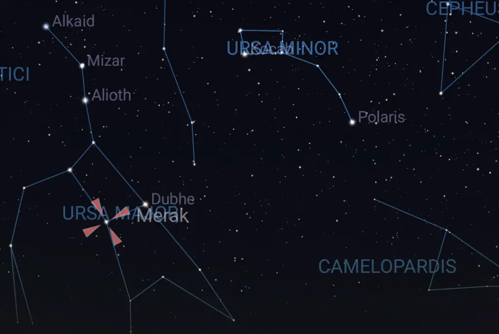
Start at Merak, follow the line through Dubhe to Polaris.
Next, follow the handle down to the spoon and look at the stars opposite of the handle of the dipper spoon. Start at the lowest star and follow the line past the other star, the one not touching the handle.
The bright star along that line is the North Star, at the end of the handle of the Little Dipper – also referred to as Ursa Minor.
How To Find Your Latitude
Once you determine the position of the North Star, assessing your latitude is easier.
The easiest way you can do that is using a sextant or a quadrant.
These tools are essential and very helpful, allowing you to measure the angle between the northern horizon and the North Star.
But how did sailors navigate by the stars before the development of such handy tools?
That’s a good question; and, as you might expect, there’s still a way to determine your latitude without access to a tool. All it takes is to extend your fist towards the horizon.
Afterward, place your fists hand-over-hand until reaching the North Star. Each fist equals roughly ten degrees.
Since Polaris is always situated within 1 degree of the celestial North Pole, if the measured angle to Polaris is 10 degrees from the horizon, this means one thing: the navigator is situated at approximately 10 degrees north of the equator.
Using this method, we’re talking about an approximate measurement. Navigators would usually increase the accuracy of this calculation by resorting to almanac corrections or simple tables.
The reason why angles are usually calculated from the horizon is that accurately determining a given point overhead – the zenith – is nearly impossible.
The word zenith comes from an Arabic expression, whose meaning is the following:
the highest level or point attained by a celestial body on its given apparent path at a particular point of observation.
You might wonder how to navigate when the location of the horizon isn’t clear. Well, in situations where the horizon was hazed or clouded, the navigator would resort to utilizing artificial horizons.
What Are Artificial Horizons?
An artificial horizon is made with using horizontal mirrors of pans with reflective fluid.
Mercury would be used most frequently.
In this scenario, the angle between the given image of the object in the sky and the reflected image in the mirror is twice the normal measurement.
Geographic North Pole And The Magnetic North Pole
Most people refer to the North Pole as simply the North.
Nevertheless, it is widely unknown that there are actually two north poles – namely the geographic North Pole and the magnetic North Pole.
When using a compass, the needle will point towards the magnetic North Pole.
But What Is The Difference Between The Two?
For one thing, the reason why there are two North Poles is that the Earth is surrounded by a magnetic field.
This magnetic field has a north and a south pole – which is precisely the end of the magnetic field.
Since the axis of the Earth doesn’t coincide correctly with the magnetic field, there are two North Poles and two South Poles.
This brings us to magnetic declination – which incorporates the distinction between the geographic North Pole and the magnetic North Pole.
Depending on your given location, the angle of the magnetic declination will vary. In specific parts of the world, the angle is bigger whereas in other parts it is smaller.
Does The Magnetic North Pole Matter Though?
Which one should you follow if you have to find your direction?
In this situation, depending entirely on a compass won’t do, as it will guide you to the magnetic North Pole. So, you should find the North Star and alter your direction accordingly.
How To Measure Longitude?
Moving onto longitude, it can be assessed in a similar way as the latitude, with some differences, of course.
If you can measure the exact angle to Polaris, then using a similar type of measurement to a star of the western or eastern horizons will help you find the longitude.
Nonetheless, the thing is that every hour, the Earth turns 15 degrees.
This is why longitudinal measurements rely on time. An error of a few minutes can lead to significant navigation errors.
Before the development of reliable chronometers, the navigator would calculate longitude measurements depending on the transit of the moon, or the location of the moons of Jupiter.
However, only professional astronomers could point them out.
This is what made the invention of the chronometer in 1761 by John Harrison a noteworthy discovery in the field of celestial navigation.
You can calculate the longitude by finding the precise local time when the sun is at its peak point in the sky.
To calculate noon, for instance, you would need to resort to a small, vertical rod driven into the ground.
You should do the reading when the shadow points north – in the northern hemisphere.
Afterward, the local reading should be subtracted from GMT (Greenwich Mean Time) or the time in England, London.
In other words, a noon reading (1200 hours) in the proximity of central Canada would be at roughly 1800 (6 pm) hours in London.
The six-hour difference between the two, it constitutes a quarter of a day, or, simply put, 90 degrees of a 360-degree circle (the Earth).
However, there is another older method of measuring longitude without exclusively relying on a chronometer – namely the lunar distance.
What Should You Know About Lunar Distance?
Now, we’d like to focus on methods of navigation.
The truth is that navigating using the stars is not as difficult as it may seem. In fact, some people even say that finding direction by depending on the stars is easier than learning how to use a compass.
We already mentioned the stars used for navigation by sailors, but there are also other elements worth noting.
How To Find The North Star?
Navigation by stars entails one essential thing: knowing how to find the North Star.
Of course, the reason why this is so important is that it indicates north (or close to it).
The North Star – namely Polaris – has a given position; to that end, it has always been situated within one degree of the celestial North Pole.
Many people think Polaris is the brightest star in the sky, but that’s a common misconception.
What is true, however, is that Polaris is the brightest star in the Ursa Minor constellation.
One way of pointing out the North Star is by locating Ursa Major in the Big Dipper – we will expand more on constellations later in the guide.
Start at Merak, follow the line through Dubhe to Polaris. Next, follow the handle down to the spoon and look at the stars opposite of the handle of the dipper spoon. Start at the lowest star and follow the line past the other star, the one not touching the handle.
The bright star along that line is the North Star, at the end of the handle of the Little Dipper – also referred to as Ursa Minor.
How To Find Your Latitude
Once you determine the position of the North Star, assessing your latitude is easier.
The easiest way you can do that is using a sextant or a quadrant.
These tools are essential and very helpful, allowing you to measure the angle between the northern horizon and the North Star.
But how did sailors navigate by the stars before the development of such handy tools?
That’s a good question; and, as you might expect, there’s still a way to determine your latitude without access to a tool. All it takes is extending your fist towards the horizon.
Afterward, place your fists hand-over-hand until reaching the North Star. Each fist equals roughly ten degrees.
Since Polaris is always situated within 1 degree of the celestial North Pole, if the measured angle to Polaris is 10 degrees from the horizon, this means one thing: the navigator is situated at approximately 10 degrees north of the equator.
Using this method, we’re talking about an approximate measurement. Navigators would usually increase the accuracy of this calculation by resorting to almanac corrections or simple tables.
The reason why angles are usually calculated from the horizon is that accurately determining a given point overhead – the zenith – is nearly impossible.
The word zenith comes from an Arabic expression, whose meaning is the following:
the highest level or point attained by a celestial body on its given apparent path at a particular point of observation.
You might wonder how to navigate when the location of the horizon isn’t clear. Well, in situations where the horizon was hazed or clouded, the navigator would resort to utilizing artificial horizons.
What Are Artificial Horizons?
An artificial horizon is made with using horizontal mirrors of pans with reflective fluid.
Mercury would be used most frequently.
In this scenario, the angle between the given image of the object in the sky and the reflected image in the mirror is twice the normal measurement.
Geographic North Pole And The Magnetic North Pole
Most people refer to the North Pole as simply the North.
Nevertheless, it is widely unknown that there are actually two north poles – namely the geographic North Pole and the magnetic North Pole.
When using a compass, the needle will point towards the magnetic North Pole.
But What Is The Difference Between The Two?
For one thing, the reason why there are two North Poles is that the Earth is surrounded by a magnetic field.
This magnetic field has a north and a south pole – which is precisely the end of the magnetic field.
Since the axis of the Earth doesn’t coincide correctly with the magnetic field, there are two North Poles and two South Poles.
This brings us to magnetic declination – which incorporates the distinction between the geographic North Pole and the magnetic North Pole.
Depending on your given location, the angle of the magnetic declination will vary. In specific parts of the world, the angle is bigger whereas in other parts it is smaller.
Does The Magnetic North Pole Matter Though?
Which one should you follow if you have to find your direction?
In this situation, depending entirely on a compass won’t do, as it will guide you to the magnetic North Pole. So, you should find the North Star and alter your direction accordingly.
How To Measure Longitude?
Moving onto longitude, it can be assessed in a similar way as the latitude, with some differences, of course.
If you can measure the exact angle to Polaris, then using a similar type of measurement to a star of the western or eastern horizons will help you find the longitude.
Nonetheless, the thing is that every hour, the Earth turns 15 degrees.
This is why longitudinal measurements rely on time. An error of a few minutes can lead to significant navigation errors.
Before the development of reliable chronometers, the navigator would calculate longitude measurements depending on the transit of the moon, or the location of the moons of Jupiter.
However, only professional astronomers could point them out.
This is what made the invention of the chronometer in 1761 by John Harrison a noteworthy discovery in the field of celestial navigation.
You can calculate the longitude by finding the precise local time when the sun is at its peak point in the sky.
To calculate noon, for instance, you would need to resort to a small, vertical rod driven into the ground.
You should do the reading when the shadow points north – in the northern hemisphere.
Afterward, the local reading should be subtracted from GMT (Greenwich Mean Time) or the time in England, London.
In other words, a noon reading (1200 hours) in the proximity of central Canada would be at roughly 1800 (6 pm) hours in London.
The six-hour difference between the two, it constitutes a quarter of a day, or, simply put, 90 degrees of a 360-degree circle (the Earth).
However, there is another older method of measuring longitude without exclusively relying on a chronometer – namely the lunar distance.
What Should You Know About Lunar Distance?
The Moon finishes a complete orbit of the Earth in roughly 27.3 days, as it moves from the West to the East.
To that end, in the course of a day, the Moon moves 13.18 degrees, in view of the Sun, planets, and stars.
Therefore, in roughly one hour, the moon will move 0.55 degrees, and in a minute, it will move 0.009 degrees.
On a different note, the almanac facilitates a range of geocentric lunar distances – specifically, the way they are likely to emerge from the center of the Earth.
Since the observer cannot find the accurate center of the moon – or of the sun, for a change, which was also used by navigators as a second object – observers would resort to collections of mathematical tables to assess the calculations.
There is actually a website that predicts the lunar distances, with really accurate measurements. You might consider visiting it if you want to expand your knowledge.
Use Of Time
Another popular method of navigating the stars is by relying on time.
So, the use of time means depending on an accurate timepiece in an attempt to assess the time of a sextant sight.
With the development of state-of-the-art technology, time has been measured with a chronometer, a quartz watch, or the time displayed on a GPS.
Traditionally speaking, a navigator would assess a chronometer from a sextant, at a specific geographic marker outlined by a certified astronomer.
Nowadays, this skill is quite rare, as most navigators can no longer do that.
At the same time, history teaches us that, in a ship, there would be three chronometers – in a dry room located in the ship.
These were primarily utilized to establish a hacking watch for the sight.
That being said, the chronometers were never exposed to outer elements – such as wind or sand. It was a navigator’s responsibility to compare and contrast the chronometers.
Brief Overview On How To Navigate Using The Stars
What are some essential tips when it comes to navigating the stars?
There’s no such thing as a singular celestial navigation formula, there are many elements worth noting.
However, we’ll try to simplify things a bit. Here are some general guidelines:
- First, you should understand and be knowledgeable about the major constellations and stars in the northern and southern hemispheres – we’ll move on to presenting the main constellations right away.
- Next, you should focus on finding the North, by positioning the star Polaris, as we already outlined beforehand.
- Find the altitude – this entails assessing the angle between Polaris’ position and the northern horizon.
- To find south, you need to point out the constellation Orion; if you can, you should position Orion’s sword.
- If you want to find your direction based on a star’s position, you should locate two stakes in the ground, which should be at a distance of 1 yard apart. Pick a bright star in the sky and, next, you should line up the star with the stakes’ tops. Afterward, wait a while until the star moves on its own from its initial position with the stakes. If the star rose, this means you are faced east. If the star went down, this means you are faced west. If the star moved to the left, this means you’re faced north. And if the star moved to the right, you’re faced south.
- You might resort to using a celestial navigation app, such as this one for the iPhone. There is also this celestial navigation app for android that can come in handy.
Constellations Used For Navigation
Ursa Major, the Big Dipper (Northern Hemisphere)
Locating this constellation is considered to be quite easy.
Nonetheless, your time and location will a big role. Ursa Major is the Latin for greater she-bear.
The reason why this constellation was given this name was that the Greeks thought that the dipper resembled the appearance of a big bear.
Each celestial navigation course mentions this constellation, being one of the most important.
Northern Hemisphere
Ursa Minor, The Little Dipper
Another important constellation located in the Northern Hemisphere is Ursa Minor – which is also referred to as Little Bear.
After positioning the Ursa Minor constellation, you’ll find it rather easy to determine the location of the North Star.
That’s because it is the last star located at the top of the handle of Ursa Minor.
Cepheus, The King
The Cepheus constellation is also known as a Greek constellation, being given the name after the mythical King Cepheus of Ethiopia.
It is the 27th largest constellation, some of its neighboring constellations being: Draco (one of the largest constellations in the sky), Camelopardalis, Cygnus, Cassiopeia, Lacerta, and Ursa Minor.
As for the Cepheus constellation, it incorporates one of the most important stars – namely the Garnet Star.
The reason why it is widely known is that it is easily recognizable, being one of the largest in the Milky Way.
Cassiopeia, The Queen
The queen constellation is part of the Perseus family. Finding the constellation in the northern night sky is relatively easy, due to its resemblance to the letter W.
Draco, The Dragon
The Draco constellation, which is Latin for the dragon, is a large constellation. And for the people living in the northern hemisphere, Draco doesn’t vanish from the horizon.
Southern Hemisphere
Carina
Moving on to the southern hemisphere, the Carina constellation is worth mentioning.
It features the second brightest star in the sky – namely Canopus, as well as other stars that are just as bright, the famous Carina Nebula and the Eta Carinae.
Centaurus
Also a Greek constellation and one of the very largest in the sky – the Centaurus constellation features two of the brightest stars, Alpha Centauri and Beta Centauri.
Crux Constellation
Crux constellation referred to as the Southern Cross is of great importance and is located in the southern hemisphere.
Don’t let its small size trick you, it is more significant for navigation than you might think at first glance.
This constellation is primarily visible in Australia and New Zealand, as it can be seen there round the year.
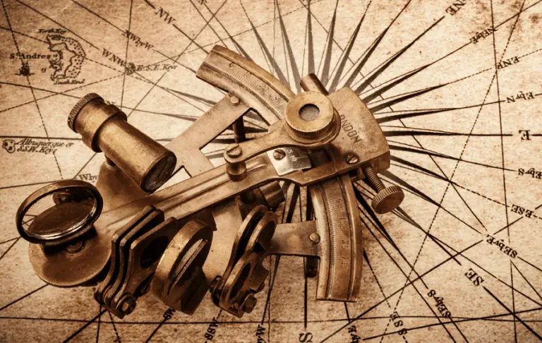
Tools and Celestial Navigation Equipment
1. Sextant
The sextant is one of the most important tools when it comes to celestial navigation.
So, what is a sextant tool, what is a sextant used for, who invented the sextant, how does a sextant work, or what is the sextant principle?
These are, perhaps, the most common questions on the topic. We’ll address each one of them.
What is a sextant?
A sextant is a tool to accurately calculate the altitude of a celestial object above the horizon.
What is a sextant used for?
The altitude measurements are used to assess the geographical position of the observer.
Who invented the sextant?
John Campbell is the one that invented the sextant – an innovation that ultimately changed the world of celestial navigation.
The history of the sextant is a pretty interesting read, too!
When it comes to the sextant parts, you should know that it incorporates a triangular frame, its bottom being a graduated arc of 60 degrees.
How does a sextant work?
The plane of the frame has a telescope horizontally attached to it. Perpendicular to the frame, a small index mirror is installed, right at the top of the movable index arm.
The radial arm is to be moved until one can point out the reflection of the star in the half-silvered mirror – it should appear through the telescope that it coincides with the horizon.
Often, the angular distance is determined from the graduated arc of the sextant.
How to use a sextant?
Moving on to using a sextant, you should note it uses two mirrors.
Usually, one of the mirrors is half-silvered; this enables the light to pass through. When you navigate, you have to look at the horizon through this mirror.
The other mirror is connected to a movable arm. The light from the sun, for instance, will be reflected in this mirror.
You can move the arm to a position where the sun’s reflection of the mirror will be reflected on the first mirror through the eyepiece.
What you will soon notice is that the object – namely the sun, is superimposed on the horizon. The given angle between the two is, many times, read off the scale. The accuracy of a sextant is its main feature.
On a different note, if you want to find out more about the marine sextant, the video above is an excellent introduction to the topic. It’s comprehensive, informative, and one of the best you can find online.
If you’re interested in getting a sextant, you can find a good one here or check out Amazon’s bestsellers below.

- Full-field dielectric Beam Converger with quartz hardcoat replaces conventional half-silvered mirror. Horizon and astrobody images are combined in a single full-field for easy, reliable sights under...
- Special mineral coating is selective for different wavelengths of light. Horizon is transmitted in one color region and the star or sun in another.
- Burch, David (Author)
- English (Publication Language)
2. Chronometer
A chronometer is also a valuable star navigation tool.
In simple terms, it is used for calculating time, depending on variations or changes in humidity, temperature, and air pressure.
In essence, Swiss watches are renowned for the most accurate chronometers as they have to be certified by the Contrôle Officiel Suisse des Chronomètres (COSC) to use the term chronometer as one of their features.
3. Accurate Watch
An accurate watch or clock is also an essential tool for navigators. In fact, navigators would use watches with sextants, for celestial sightings.
It’s important for the watch to be set to the minute. An error of as little as 30 seconds could lead to a navigational error of up to 12 kilometers.
Of course, getting the best accurate watch can seem a tad difficult, considering the diversity of products you can find on the marketplace.
This guide on outdoor watches is a nice resource for that or get a quick peek from the list below.

- Make a bold statement with this rugged GPS smartwatch, featuring a vibrant 1.2” AMOLED display and up to 18 days of battery life
- Engineered with a supertough 45 mm fiber-reinforced polymer case and metal-reinforced bezel

- Make a bold statement with this rugged GPS smartwatch, featuring a 0.9” display with solar charging lens and unlimited battery life with solar charging (assumes all-day wear with 3 hours per day...
- Engineered with a supertough 45 mm fiber-reinforced polymer case and metal-reinforced bezel
4. Sight Reduction Worksheet
Moving on to sight reduction worksheets, these were used to analyze different sights (data obtained from sextants at given times) in an attempt to determine the longitude and latitude.
5. Current Nautical Almanac
We’ve already mentioned several times that nautical almanacs were a huge aid for navigators.
While being knowledgeable regarding celestial navigation stars was useful, an almanac was useful for several reasons.
The nautical almanac incorporates tabulations of the Sun, Moon, navigational stars and planets – information that helps navigators find their position and practically no one could memorize!
6. Star Compass
Another key tool is the star compass. But what is a star compass? Want to know how to use a star compass?
This instrument is metal tool that divides the horizon into quarters or equal parts known as houses.
Each house on the horizon contributes to memorizing the positioning and paths of the stars.
The star compass represents the foundation for the navigation system.
On a different note, one might also resort to using star maps to find the constellations that are more visible during a certain month.
Celestial Navigation In Modern Times
Over the years, celestial navigation has been marked by several inventions – perhaps the most notable one has been the development of the sextant, as well as the inclusion of the tools we mentioned in the list above.
Still, regardless of the appearance of relatively inexpensive instruments, such as the run-of-the-mill GPS, prudent mariners in modern times have to showcase basic knowledge of celestial navigation in examinations just in case those tools fail.
Until 1997, celestial navigation was still taught in the US Marine and US Navy, primarily due to the fact that it doesn’t give off signals that can be discovered by the enemy.
The Future Of Celestial Navigation
In the spring of 1993, the US Navy officially announced that the course on celestial navigation was to be discontinued.
That’s specifically because it was recognized as one of the most demanding and time-consuming non-engineering courses.
However, it is taught at Harvard, for instance, as Astronomy 2.
While we can say that the knowledge of celestial navigation won’t vanish, the ever-changing world we live is characterized by fluidity.
So, it’s hard to make any predictions!
Additional Information On Celestial Navigation
How To Navigate By The Stars In The Southern Hemisphere?
Navigating in the Southern Hemisphere just requires being acquainted with the main constellations.
Similar to the Northern Hemisphere, which has an essential star – namely Polaris – the Southern Hemisphere has Sigma Octantis, which is located in close proximity to the South Pole.
The group of stars known as the Crux constellation (which we included above) is used for navigation purposes in the Southern Hemisphere.
To navigate, you will need to get acquainted with the names of the stars in the Crux constellation.
Finding South is possible by invisibly drawing a line between Acrux and Gacrux – you must further extend that line by 4.5 times.
The end of the line will overlap with the southern celestial pole.
After drawing another line, your body will be in the correct direction – the east being to your left, with the north being right behind you.
What Animals Use Stars To Navigate?
There are numerous animals that use star navigation.
We’re talking about birds, fish, butterflies, bees, sea turtles, reptiles, ants and sand hoppers.
It is interesting to point out that the Norsemen had quite a specific navigational system.
In essence, the stars aren’t visible at all times; for instance, in the summertime, at high latitudes, not all constellations are distinguishable.
This is why the Norsemen analyzed the behavior of the birds.
For example, one of the very first Norwegian sailors that embarked on an exploration journey towards Iceland had the habit of keeping several ravens on their vessel, to determine the positioning of the land.
They would send them out in different directions and if they returned that meant that there was nothing in that particular direction. If they didn’t return, the ravens have found the land, much like the story of Noah in the Bible.
The key achievement was that they could find their way back easily somehow. Some theorize that it’s similar to insects using the moon to navigate at night.
With that in mind, it’s clear animals have a high level of sensitivity when it comes to navigation in general and likely celestial navigation.
Final Thoughts
Know the stars and you will always have a compass (The Revenant)
At this point in our guide on celestial navigation, you have a good basis of knowledge. Now, you just need a few tools and practice!
If you want to find out more information about this exciting science, we advise you to get a celestial navigation book to have a deeper understanding of the topic.
This will help you if you have further questions such as how to navigate using the sun, what you should know about the line of position celestial navigation, what is Arab star navigation, etc.
Indeed, this domain has much more in store for you than you could possibly imagine!
If you’re still hungry for more information, below is a 3-hour easy-to-understand introductory guide on the topic of celestial navigation. It also features the basics of using a sextant.
If you’re looking to complete your emergency medical kit, you can start with our article on the best trauma shears.
Reference List
- https://en.wikipedia.org/wiki/Celestial_navigation#Angular_measurement
- https://www.citylab.com/life/2013/04/7-examples-how-we-used-navigate-world-around-us/5286/
- https://www.celestaire.com/how-does-celestial-navigation-work/
- http://onboardintelligence.com/CelestialNav/Celnav1.aspx?AspxAutoDetectCookieSupport=1
- https://www.getmyboat.com/resources/boating-how-to/255/a-brief-overview-of-celestial-navigation/
- https://www.britannica.com/science/celestial-navigation
- https://www.quora.com/How-does-celestial-navigation-work
- https://www.naturalnavigator.com/the-library/celestial-navigation/
- https://www.naturalnavigator.com/find-your-way-using/stars/
- https://www.quora.com/How-do-I-navigate-using-the-stars
- https://www.rustico.com/blogs/news/how-to-navigate-using-the-stars
- https://www.arabamerica.com/arab-contributions-geography-navigation/
- https://astronavigationdemystified.com/lunar-distance/
- http://www.jgiesen.de/LunarDistance/index.html
- https://www.wikihow.com/Navigate-by-the-Stars
- https://www.backpacker.com/survival/how-to-navigate-by-the-stars
- https://www.celestaire.com/using-a-sextant/
- https://www.encyclopedia.com/science-and-technology/astronomy-and-space-exploration/astronomy-general/sextant
- https://www.starpath.com/catalog/books/1898.htm
- http://www.hokulea.com/education-at-sea/polynesian-navigation/the-star-compass/
- https://en.wikipedia.org/wiki/Celestial_navigation#Modern_celestial_navigation
- https://www.woodland-ways.co.uk/blog/others/natural-navigation-in-the-southern-hemisphere/
- https://en.wikipedia.org/wiki/Animal_navigation
Have raccoons invaded your backyard? Learn how to get rid of them quickly from our article on how to scare a raccoon!
Last update on 2026-07-05 / Images from Amazon Product API
thanks for all the work!
Glad you enjoyed it!
In a former life, I was a young Coast and Geodetic Officer aboard the USC&GSS Oceanographer. We were trained to obtain sextant based sun and morning/evening star shots and reduce the information to plotted lines used for navigation. That was in 1967. Interestingly though was an ongoing evaluation that was operated by myself to evaluate and compare celestial, Loran A, Loran C and Omega (VLF) forms of navigation with a clunky, ‘new fangled’ rack of electronics offered up by MIT Labs just for our use. It was one of the first practical satellite navigation systems (early version called Transit). It was a whole electronic rack, floor to ceiling, including the latest paper tape run computer that whirred and did its magic every time there was a predicted satellite rise time! To my knowledge, it was the first public debut of a system previously restricted to US Navy capital ships and submarines. At the end of an eight month trip around the world, the sextants went to the surplus heap. You might be interested to know that the first four methods were all pretty close in error bands with the fifth an obvious winner. It remains to this day as the only navigation method with a certifiably accurate and consistent error band. Thanks for your article!
Thank you for sharing, Glenn! I am glad you enjoyed the article. If you know anyone else that would be interested, feel free to share!
I liked this a lot! Your clear writing stirred up things I learned in college in the 50s. I remember the old ships’ gyroscopes. On PanAm flights across the Pacific, in the 60’s, the plane’s Navigator opened a roof port and checked the ship’s gyro against the stars. The Sperry gyro on our research vessel Acania was very good but the Captain checked the stars every clear night. We got down to Eniwetok and back without a hitch. Now my iPhone seems to have a built in compass! I wish I could see the stars here in Silicon Valley but to do so means a 4 hour drive to the Sierra Nevada mountains East of here! My friend Penny Setterfield knows about the signs in the stars one finds in the Bible. On my web site somewhere! Thank you!